Boise Open Space – Stack Rock Reserve Recreational Trail Feasibility Study and Environmental Assessment
Bryan Brown
Department of Environmental Studies
Introduction
Through the Boise Open Space initiative, voter-approved tax levies have been used to fund the protection and reservation of lands in the Boise Foothills and improve public access and connectivity.
The Stack Rock Reserve was identified as an area that could use recreation improvements. The current access is temporary and revocable as it crosses private lands.
A feasibility study was designed to evaluate 3 alternative solutions for permanent public access. An Environmental Assessment was conducted to evaluate adverse impact potential of relocating the trail in Alternative C, the recommended solution of the feasibility study.
Alternative A – Acquisition of Private Land Parcels
Levy funds for the Open Space Initiative have been used to acquire land in the past, including 840 acres expanding Stack Rock reserve in November of 2017. The 120 acres in this alternative are undeveloped timberland located in Boise County and both parcels are owned by the same entity.
Pros
- Would add to City owned open space reserves, improve connectivity
- Permanent solution
- Aligns with Open Space objectives
- Protects watershed, wildlife habitat and provides more recreation area
Cons
- Most expensive
- Voluntary sale
- Lower priority acquisition area
Feasibility Determination
Due to the estimated cost, voluntary sale, and lower priority location, this alternative solution is second-most feasible
Alternative B – Acquisition of Permanent Easement
Easements are rights to access and use land. Easement holders do not actually own the underlying land, but can hold permanent rights to use if granted by the land owner and secured legally. Permanent easements stay effective on the land even if it is sold, so they can be considered an encumbrance to the property owner. The City has acquired easements through donation and purchase for access and recreation in the past, including for the Sweet Connie Trail, which passes through the Daniel’s Creek property, just south of Stack Rock Reserve. The current trail has revocable easement access granted.
Pros
- Revocable easement could be made permanent, no new trail impacts to environment
- Inexpensive solution to permanent access
Cons
- Voluntary sale – encumbers title to land
- Difficult to value
- Trespass issues outside of easement
- Could be impacted by land use changes
Feasibility Determination
Due to the easement encumbrance, voluntary sale, valuation issues, and future trespass issues, this alternative is the least feasible for providing permanent access.
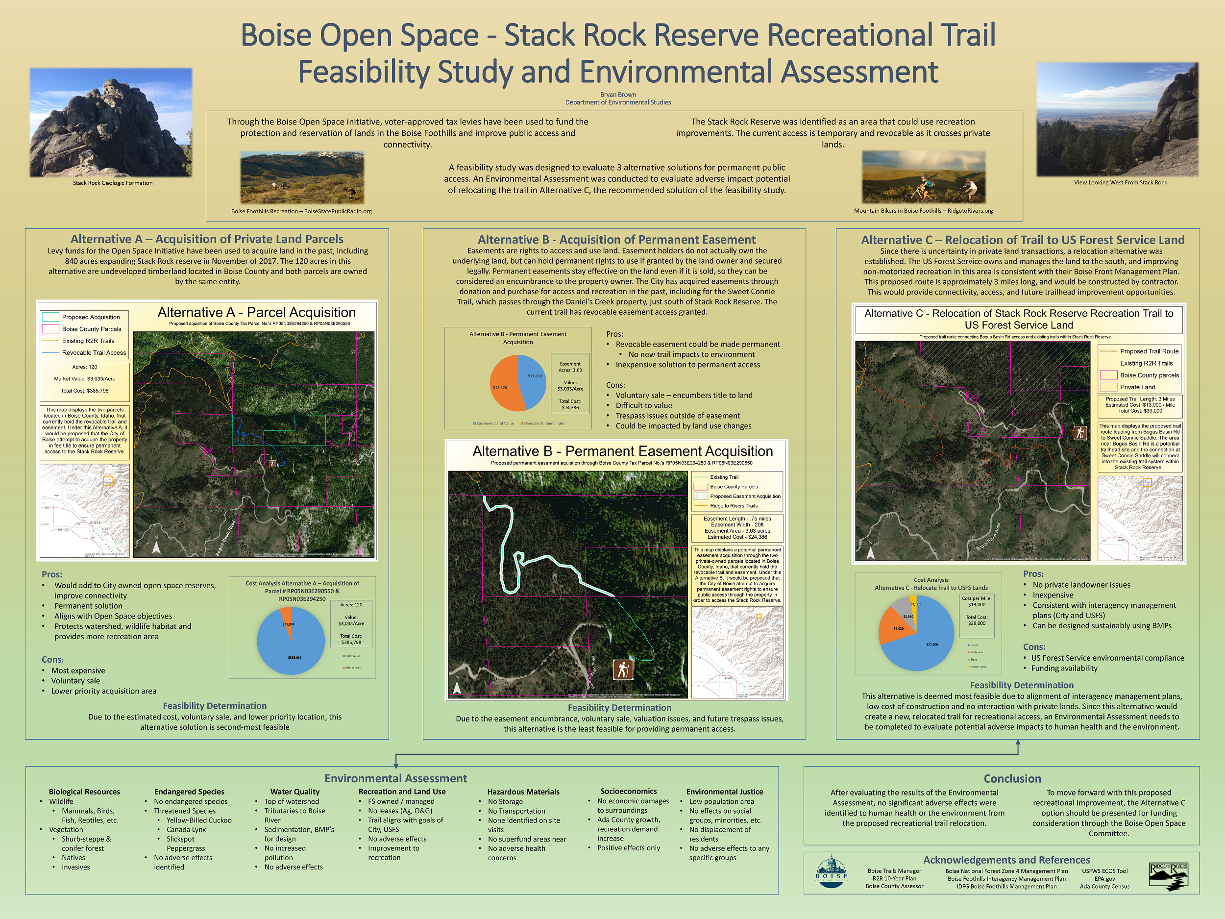
Alternative C – Relocation of Trail to US Forest Service Land
Since there is uncertainty in private land transactions, a relocation alternative was established. The US Forest Service owns and manages the land to the south, and improving non-motorized recreation in this area is consistent with their Boise Front Management Plan. This proposed route is approximately 3 miles long, and would be constructed by contractor. This would provide connectivity, access, and future trailhead improvement opportunities.
Pros
- No private landowner issues
- Inexpensive
- Consistent with interagency management plans (City and USFS)
- Can be designed sustainably using BMPs
Cons
- US Forest Service environmental compliance
- Funding availability
Feasibility Determination
This alternative is deemed most feasible due to alignment of interagency management plans, low cost of construction and no interaction with private lands. Since this alternative would create a new, relocated trail for recreational access, an Environmental Assessment needs to be completed to evaluate potential adverse impacts to human health and the environment.
Environmental Assessment
Biological Resources
Wildlife
- Mammals, Birds,
Fish, Reptiles, etc.
Vegetation
- Shurb-steppe & conifer forest
- Natives
- Invasives
Endangered Species
No endangered species
Threatened Species
- Yellow-Billed Cuckoo
- Canada Lynx
- Slickspot Peppergrass
No adverse effects identified
Water Quality
- Top of watershed
- Tributaries to Boise River
- Sedimentation, BMP’s for design
- No increased pollution
- No adverse effects
Recreation and Land Use
- FS owned / managed
- No leases (Ag, O&G)
- Trail aligns with goals of City, USFS
- No adverse effects
- Improvement to recreation
Hazardous Materials
- No Storage
- No Transportation
- None identified on site visits
- No superfund areas near
- No adverse health concerns
Socioeconomics
- No economic damages to surroundings
- Ada County growth, recreation demand increase
- Positive effects only
Environmental Justice
- Low population area
- No effects on social groups, minorities, etc.
- No displacement of residents
- No adverse effects to any specific groups
Conclusion
After evaluating the results of the Environmental Assessment, no significant adverse effects were identified to human health or the environment from the proposed recreational trail relocation. To move forward with this proposed recreational improvement, the Alternative C
option should be presented for funding consideration through the Boise Open Space Committee.
Acknowledgements and References
- Boise Trails Manager
- R2R 10-Year Plan
- Boise County AssessorBoise National Forest Zone 4 Management Plan
- Boise Foothills Interagency Management Plan
- IDFG Boise Foothills Management Plan
- USFWS ECOS Tool
- EPA.gov
- Ada County Census