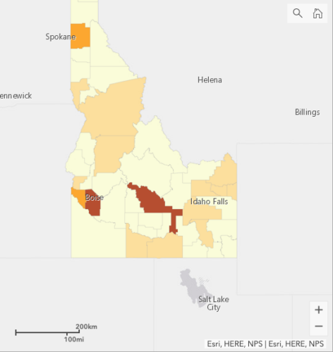
A new interactive map created by Boise State graduate students gives Idaho residents up-to-date information on the number and location of COVID-19 cases within the state.
Counties are color coded to better illustrate the number of cases across Idaho. A line graph also shows the increase in the number of cases over time. A sidebar to the right of the map displays community resources and ways viewers can help. (For instance, Boise State has set up an emergency fund to support students. The United Way also has set up a COVID-19 Response Fund for Idaho.)
“As disaster communication researchers, we know that sharing accurate and timely information does not propagate fear and panic, but rather fosters trust and more accurate perceptions of the risk,” said Brittany Brand, an associate professor of geosciences and director of Boise State’s new Hazard and Climate Resilience Institute. “Our motivation is that visualizing the COVID-19 cases by location across Idaho and seeing how rapid the cases grow, via the graph, will help residents realize how serious COVID-19 really is, motivating them to take action.”
The map itself was created by Carson MacPherson-Krutsky, a Boise State geosciences doctoral student; Katie McConnell a doctoral student from Yale; and Lauren Hunt a doctoral student in Boise State’s human environment systems program. All three students are affiliated with the Hazard and Climate Resilience Institute.
The map was created using the ArcGIS story map platform. Confirmed cases are updated daily by members of the institute, using data pulled from the Idaho webpage for the Novel Coronavirus/COVID-19.
“We hope to see this increase begin to flatten over the coming weeks as residents follow the governor’s order to stay at home for 21 days,” Brand said. “We also display relevant community resources, such as how to find your local food bank, and state and national recommendations for protecting yourself.”
In addition to the map, members of the Hazard and Climate Resilience Institute are submitting a National Science Foundation grant to extend findings of two previous studies: one dealing with natural hazard risk perception and preparedness behavior, and another that assessed the influence of cultural variables on household emergency preparedness.
“Both of these studies were conducted within the last year, and provide pre-COVID-19 data on hazard beliefs and preparedness behavior, such as storing water, food and prescription medicines. We have an opportunity to compare those pre-COVID-19 preparedness data to concurrent COVID-19 preparedness behavior, and further explore how the perceptions of the current pandemic (e.g., threat severity, immediacy and duration; effectiveness of protective actions) influence protective action behavior,” Brand said.
“In addition to the intellectual merit of advancing scientific understanding of people’s responses to a broad range of environmental threats, this project will have the broader impact of providing data to health professionals and emergency managers that can inform their messaging in current and future events.”
Resiliency isn’t just about being prepared to meet a community’s physical needs during times of crisis. Brand reminded people that attitude counts, as well.
“We realize that these are challenging times, both emotionally and for many of us financially. Try to stay positive. You may be practicing social distancing, but that doesn’t mean we cannot smile and wave, sending positive energy to those around us. Be kind, be patient and be diligent in your practice to stop the spread of COVID-19.”
To learn about other hazards in Idaho and how to be prepared for them, check out the Hazard and Climate Resilience Institute website, or email hcri@boisestate.edu with questions or to find out how to get involved.