
Christopher Mathias is a veteran of the U.S. Coast Guard. He holds a law degree from Vermont Law School and Ph.D. in Law and Public Policy from Northeastern University with a focus on homeland security. He graduated cum laude from Boise State with a degree in Criminal Justice. Dr. Mathias wears many hats. He is the Policy Manager at Boise State, Adjunct Graduate Professor in the Department of Public Policy and Administration and an independent homeland security consultant specializing in state, local and private sector affairs.
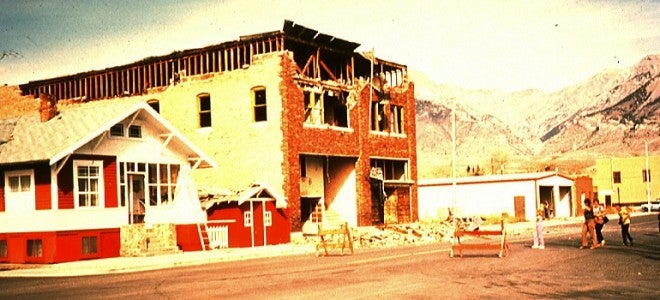
The Borah Peak Earthquake struck around eight in the morning on Friday, October 28th, 1983. The big shake registered 7.3 on the Richter scale; it killed two schoolchildren and caused about $12 million in property damage. The emergency response, however, and how a state like Idaho might fare in the wake of a similar disaster today has not been sufficiently discussed.
At the time of the quake, the media and policy makers received some criticism. According to then-Custer County Assessor Bob Savage, “the media caused more problems than anything else – the low-flying planes and they kept phone lines tied up so no one could get through.” Another close observer, Bob Smith at the University of Utah, told the Associated Press that those in a position to act on the quake data, “the land-use planners, the legislative people… seem to operate on short-term problems. The lessons learned from Borah Peak don’t seem to have made much of an impact.”
Since something similar will happen again, the 30th anniversary of the Borah Peak quake is a good time to examine the state of incident management in Idaho.
The National Incident Management System (NIMS) is a proxy here for incident management. It’s a comprehensive national framework in which public and private entities cooperate to manage domestic incidents. The NIMS is not an emergency operations plan; it is a set of concepts that crosses disciplines and government levels so incident managers are on the same page while training, preparing, responding to and recovering from catastrophic events.
Today, every state employs the NIMS. Comparing the quite dissimilar states of Idaho and Massachusetts, my graduate research examined the efforts of state employees who work on “NIMS compliance,” a version of what academics call “policy implementation.” This essay proceeds in four parts. It first briefly outlines Idaho’s incident management structure. Second, it discusses similarities between the NIMS in Idaho and Massachusetts and then the differences. Finally, it asks, “so what?”
IDAHO’S INCIDENT MANAGEMENT STRUCTURE
Incident management is a critical component of homeland security and a proper function of government. Observers identify four different models for how state governments manage incidents, emergency preparedness and other homeland security functions. Idaho employs the adjutant general model (one of 11 states to do so). Under this model, the executive branch, primarily in the Bureau of Homeland Security (BHS), coordinates homeland security activity. The BHS director reports to the adjutant general of the Idaho Army National Guard who advises the governor.
The Idaho Legislature is pretty quiet in this arena; it has no standing committee for any homeland security function. Its last substantial, non-budgetary contribution to incident management was in 2004 when it passed a broad homeland security bill. The State Disaster Preparedness Act created the BHS to effectuate “Homeland Security and Emergency Management” strategies.
On July 16, 2010, Governor C.L. Butch Otter issued Executive Order 2010-09 requiring all state agencies to adopt the NIMS. The Order requires the Adjutant General and the BHS to “prepare for and respond to emergencies or disasters within the State of Idaho in a manner consistent with the [NIMS].”
IDAHO VERSUS MASSACHUSETTS
Though the states are dissimilar, those who work on NIMS compliance in Idaho echoed most of the same themes as their Massachusetts counterparts. For example, across states, they universally support the theory that the NIMS is essential to homeland security. They also tell similar tales about the history of the NIMS: it was hard to implement initially and though challenges remain, things have gotten noticeably better in recent years.
Additionally, officials in both states view private sector and volunteer groups as active and valuable participants in NIMS compliance. They also realize that while ‘civilians’ have spoken and unspoken expectations for incident managers, neither the media nor the public are familiar with the NIMS. The cross-state parallels, however, give way to five notable differences.
First, the good news: Idaho’s incident management apparatus is smaller and less complex. Theoretically, Idaho, with its small and isolable government, has a more manageable path to desired incident management outcomes.
Second, Idaho more actively manages private sector participation in incident management. This could be because (a) its history of wildfire provided recurring opportunities to engage citizen-volunteers and private aid groups or (b) its comparative poverty drove the need to galvanize the private sector’s incident management strengths.
Unsurprisingly and unfortunately, Idaho has fewer resources for incident management. And when allocating those funds to state agencies and local governments, first responders are heavily favored over non-first responders. Idaho’s non-first responders seem resigned to this understandable but discriminatory reality.
Fourth, Idaho is a less active administrator of the media’s participation in incident management activities. By contrast, media in Massachusetts are regularly invited to participate in drills and other training exercises.
Fifth, Idaho’s incident management apparatus seems less integrated. Regular interactions are far more common in Massachusetts. This may be because intrastate travel in Massachusetts is cheaper than comparable travel in Idaho, a state larger than the six New England states combined. And should it aim to reduce travel costs, Massachusetts has tremendous capacity to employ web-based conferencing (Idaho has among the lowest bandwidths in the United States; Massachusetts has among the highest).
IDAHO: STRONG PRIVATE SECTOR, WEAK CONNECTIVITY
Two themes recurred heavily and may have the greatest implications for incident management in Idaho: the private sector and the internet.
For most people, incident management is subconsciously viewed through a public-governmental-lens. However, volunteers, small business owners, and consultants in academia or the private sector, play a critical role in incident management. The morning after the Boston Marathon bombings, I wrote:
When we think of homeland security and incident management, we tend to think of ‘critical infrastructure’ through a public sector lens. But we’ve learned that a substantial portion of incident management activities take place on and with private property. Indeed, New England’s tallest building (the John Hancock Tower) is privately owned and a stone’s throw from the blast sites. Hopefully the owners and property managers had engaged Massachusetts’ incident managers and learned how to coordinate and work together in situations like this.Christopher Mathias
Those in the private sector need to be equitable partners in incident management. The government can’t, doesn’t and shouldn’t do incident management by itself.
Those outside government have incentive to participate in incident management planning. Consider, for example, the paradox of incident management — the more dire the need for emergency responders, the less likely they are to be available. Thus, private citizens have incentive to help effectuate a post-incident reality where desperation is minimized and emergency assistance is efficiently and effectively accessible.
Fortunately, in addition to members of Idaho Voluntary Organizations Active in Disaster, some private citizens in Idaho are stepping up. This is unsurprising, as my research found Idaho is better at galvanizing the participation of non-governmental parties. Until the next big shake, those inside and outside government need to be equitable partners in incident management.
The internet in Idaho, on the other hand, may be a major challenge.
During my years of fieldwork, it was common for incident managers to mention the internet as a common source of on-the-job assistance. The internet is a major communications tool because it makes information cheaper and it is a place where information gathers in droves and is shared at rapid rates. In other words, it is a major tool used by incident managers throughout the lifecycle of incident management — plan, train, execute, recover, assess, start over.
Unfortunately, for reasons of microeconomics, geography and demography, Idaho does not have as much internet bandwidth as the other states. More discussion with those in the field is necessary to answer the question of how bigger (internet) pipes could strengthen Idaho’s incident management apparatus. But bigger pipes could mean more money for other needs.
Over the last decade, research about homeland security funding has largely focused on how such funds are allocated — who gets what and why. My research suggests spending patterns are equally revelatory. Because Idaho is comparatively large and poor, it is forced to dedicate a higher percentage of its resources to, among other things, intrastate travel. A stronger internet could “shrink Idaho” by enabling more regular face to face contact, training and exercising. This would offset some travel costs; the savings could be repurposed. More research is needed to fully comprehend the internet’s role in Idaho’s incident management efforts.
In conclusion, though some indicated that lessons were not learned from the last big shake, my research leads me to disagree. Indeed, a veteran of incident management in Idaho once told me that Idaho has come “a long way” since the last big shake. Incident management in Idaho faces many of the same hurdles and challenges as it does in other states. But it has some unique challenges (beyond the proverbial “lack of resources”). Idaho’s lack of bandwidth means information about probable security threats – drought, dam breaks, livestock disease and earthquakes – is more expensive, more slowly shared and therefore less plentiful. Fortunately, Idahoans have a small and isolable government and tremendous incentive to help it prepare for the next big shake. Thus, in the three decades since the Borah Peak quake, incident management in Idaho has matured and evolved, but challenges abound.
Visualization of the quake from Idaho State University
Video does not have captions as there is no dialogue. Descriptive transcript is provided on this page.

Descriptive Transcript
[Siren sounds]
[Title] Borah Peak Earthquake 1983
[Low rumble, view of earth spinning in space, stops on North America]
[Text] October 28, 2983 a day of change in Idaho’s history.
[Zoom in on earth, area of earthquake’s epicenter is circled]
[Siren and low rumbles continue]
[Text] Epicenter, 20 miles northwest of Mackay, ID
[upbeat music]
[zoom out, visual of landslide path with earthquake historic marker, start and end scarp lines]
[Text] A 23 miles crack (fault scarp) opened like a zipper from South to North
[view of scarpline on map]
[Text] Maximum height offset: 3 meters (image from R.C. Buckman, U.S. Geological Survey
[zoom in to start of scarpline on map]
[Text] The Borah Peak Mountain Range]
[photos of Borah Peak Mountain Range and Scarpline]
[Text] Earthquake: 7.3 on Richter scale
[zoom to landslide on map]
[Text] One of the strongest in the US
[LIDAR image] Landslide visualized with LIDAR data
[zoom to Earthquake historic marker on map with photo overlay]
[Text] Change in groundwater pressure altered hydrology
[image of mountain range with flooded field in foreground]
[Text] A hot-water spring dried up, but reappeared triple its flow, flooding houses (photo by Sue Villard, Challis, ID Courtesy of The Challis Messenger)
[zoom to end of Scarp Line on map, Google Earth 3D tour]
[LIDAR image]
[Text] LiDAR visualization following scarp linke from end to start
[Text] LIDAR helps measuring vertical and horizontal offsets from earthquakes, Assembled using ENVI and ArcScene. Speckes are dense trees or shrubs. Geospatial technology provides important vizualization and analysis tools.
[Google earth map of area]
[Text] Earthquakes seriously affect human life. Two people lost their lives.
[zoom to city of Mackay, Idaho]
[Newspaper graphic with headline $12.5 million in damage, October 28, 2983]
[siren sounds an low rumbles]
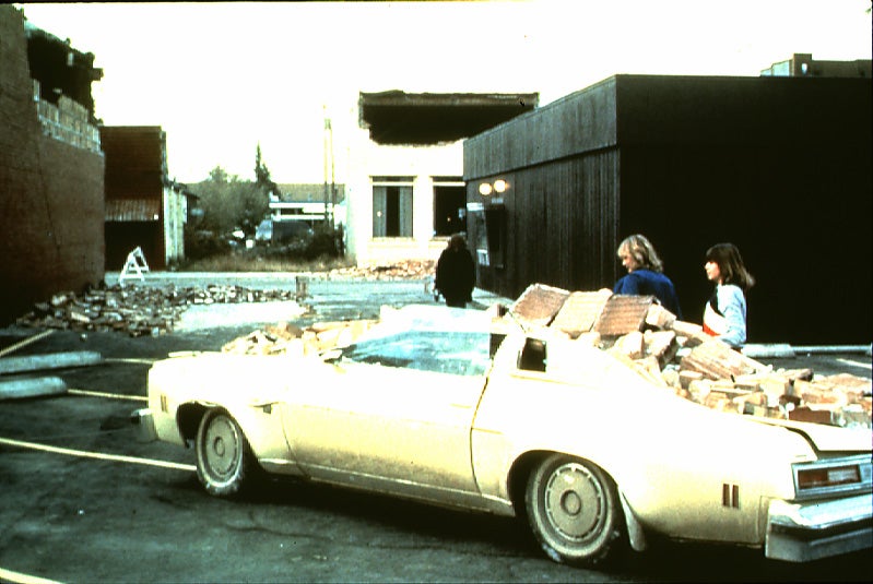
[image of a damaged car, and the large boulder that hit it]
[image of building with part of the roof collapsed (photo by Dave LaBelle, Courtesy of the Odgen Standard Examiner)]
[image of moutain peak behind rolling green hills] Southwest Idaho is still an active earthquake area
[Text] Teaching material available. Developed in partnership with Idaho Falls School District
[Credits] Idaho State University Geosciences Department. Dr. Sylvio Mannel, Sylvio@Mannel.com; Dr. Nancy Glenn, glennanc@isu.edu; Sara Ehinger; Carol Moore; Dr. Dave Rodgers; Earthquake Quartet #1 by Andrew Michael; Pictures Sylvio Mannel if not otherwise labeled. Post-Register; November 28, 1983. R.L. Whitehead, R.W. Harper and H.G. Sisco, 1984. GeoNote 05, Breckenridge (1986) Idaho Geological Survey. Supported by NSF Idaho EPSCoR Program by the National Science Foundation award #EPS-0814387. LiDAR data collection funded by NASA EPSCoR. For Teaching Material contact: Sylvio@Mannel.com or glennanc@isu.edu. 2009