By: Jules de la Cruz
Artificial brightening of the night sky — also known as light pollution — has become a significant issue in the past few decades. As the amount of unilluminated territory worldwide dwindles, areas established to protect and prioritize natural darkness have become a scarce and highly valuable resource. While their value is certainly connected to recreational usage and tourism, it extends beyond that, acting as a sanctuary for ecological, cultural, and astronomical purposes as well. The Central Idaho Dark Sky Reserve is one of the few parcels of land designated for preserving darkness and the first gold-tier dark sky preserve in the United States. Officially established by the IDA in 2017, it was created to protect the sanctity of nighttime from light pollution. However, as cities surrounding the reserve intensify their artificial lighting regimes, the need to monitor light pollution within the reserve itself becomes essential.
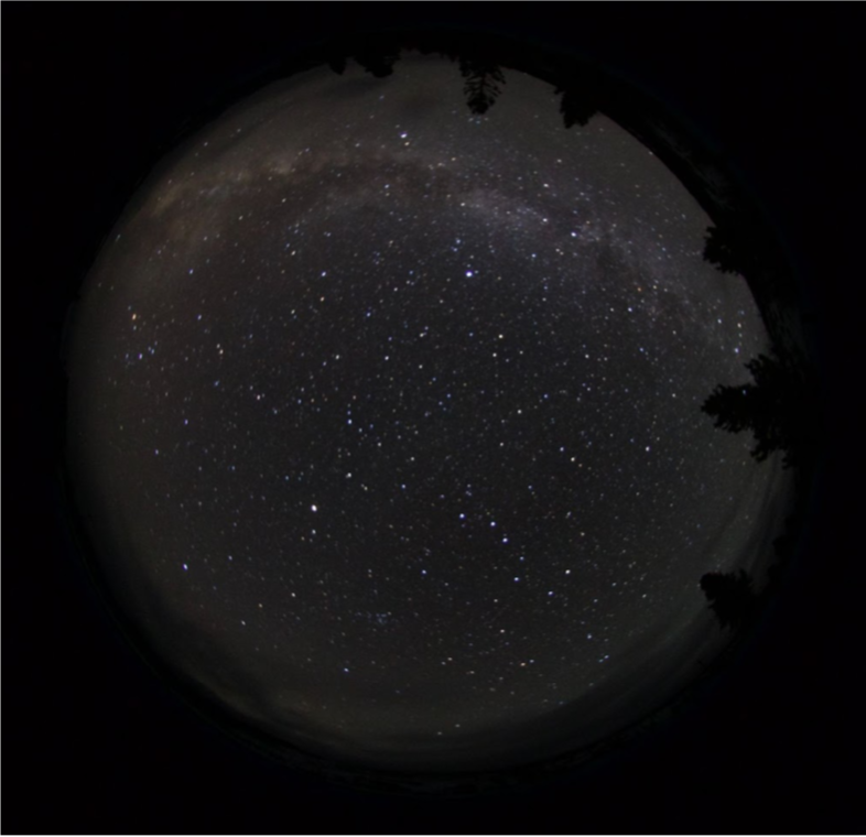
Night sky brightness, and how it is affected by light pollution, can be measured through multiple methods and variables. Some common properties used to characterize the night sky include (ir)radiance, (il)luminance, zenith brightness, correlated color temperature (CCT), the Bortle scale, and limiting magnitude. Similar to the number of properties, a range of methods and equipment can be used to measure night sky brightness. One such method is the Sky Quality Camera (SQC). Developed by Andrej Mohar, the SQC is a software program combined with a Digital Single Lens Reflex (DSLR) camera equipped with a fisheye lens. The visual distortion produced as a result of the ultra wide-angle of the lens is important for night sky imaging and analysis, as it allows the camera — and therefore the software — to capture a hemispherical view containing the ground, sky, and horizon when pointed towards the zenith (straight up). The horizon is of particular interest for light pollution analyses because it is the area where interaction between artificial light sources on the surface and the atmosphere are most prominent. Once the position of the camera is properly set up, the exposure setting must be determined based on the luminous environment. Extremely dark locations, like the reserve, require longer exposure times, upwards of 2 minutes, to capture as much light as possible. In these cases, a bulb controlling the shutter speed must be attached to the camera and manually operated for the duration of the image, since most DSLR exposure settings only allow for a maximum of 30 seconds. Conversely, locations with high levels of illumination, like Los Angeles, require much shorter exposure times, to prevent the exorbitant amounts of light from oversaturating the image. The raw SQC images below demonstrate the different luminous environments and why they require exposure settings unique to their needs.
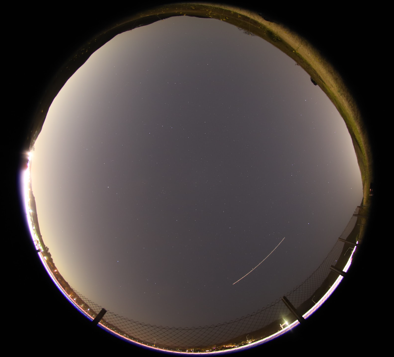
Photo by Travis Longcore
The images are then saved and downloaded to a computer as a RAW file, which is a digital image format that is minimally processed and uncompressed. Although they take up more space than other formats, such as JPG, shooting in RAW ensures that all image data is retained. This is vital for the next component of the SQC, which is software analysis. Once an image is opened using the SQC program, it requires various information to calibrate its analysis. Time, latitude, and longitude are used as inputs by the program to align the image with the brightest stars. Additionally, humidity, temperature, and elevation serve as reference conditions. Depending on the accuracy of the information given to the software, it will rotate the image to align with the correct position of stars at a given time and location. Manually creating the sky border ensures that analysis is confined to the sky, and therefore that all derived measurements are of the sky itself, and not the surface.
Once the sky border is set, creating points within it that differentiate between clear skies and clouds teaches the SQC how to recognize unobstructed areas in the image to be used in night sky brightness analysis. The final step is adding the coordinates and azimuth angles of light pollution sources near the image location. The azimuth angle describes in which direction a light pollution source starts and ends. Providing this information allows the software to calculate which sources are responsible for the various contributions of light pollution in a given location. Once the SQC has been fed an adequate amount of information, it can run an automatic analysis on the image that generates specific aspects of the sky such as sky brightness (magnitude per arcsecond squared), luminance (microcandela per meter squared), correlated color temperature (Kelvin), and cloud coverage percentage. In addition to automatic analysis, the SQC also has a ‘Prediction Simulation’ tool that can represent the change in night sky brightness under various potential scenarios, such as the percentage of white LEDs and the annual change in lamp power/quality. Below is an example of the automatic analysis provided by the SQC.
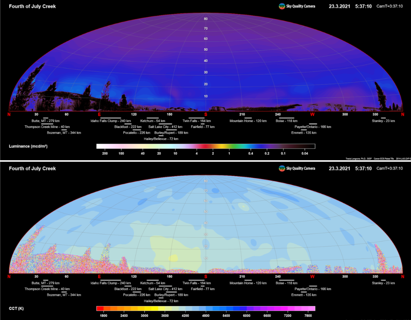
The SQC can be used in the Central Idaho Dark Sky Reserve to analyze the quality of the night skies and identify sources of light pollution. A study (Light pollution research, mitigation, and analyses in and around the CIDSR) conducted in 2021 by the UCLA IoES Practicum identified a range of sources including the Thompson Creek Mine, Ketchum, and even farther away metropolitan areas such as Boise. Additionally, their prediction analysis yielded the greatest increase in night sky brightness in simulations focusing on 6% annual growth in lamp power/quality and 100% conversion to LEDs by the target year 2051. Continued monitoring with the SQC of established sites within the reserve is vital to understand the external forces at play in disturbing the CIDSR’s pristine skies. Combining the in situ measurements with VIIRS satellite data of upwards radiance (for which more information can be found here Shining a Light on Light Pollution in CIDSR, Google Doc) can paint a near complete picture of the reserve’s skies and possible threats to it, allowing for more effective monitoring efforts and providing advanced notice if action needs to be taken to protect the dark sky.