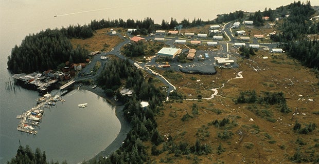
In 1964, a massive 9.2 earthquake hit the Prince William Sound of southern Alaska. Just four minutes later, a tsunami engulfed Chenega, in the Dangerous Passage fjord, killing 23 of the coastal village’s 75 residents and destroying the town. The quake is the second most powerful on record, just behind the 1960 Valdivia, Chile, temblor.
For decades, no one knew for certain what caused the disaster at Chenega. Several other towns also experienced tsunamis after the earthquake, including Valdez, Seward and Whittier, but scientists were able to connect those with known shallow-water landslides. In Chenega, there was no evidence of a landslide in shallow waters, and the technology available at the time did not allow for measurement of the area’s deep-water cove.

Lee Liberty
That question has now been put to rest by a team of scientists including Boise State geoscientist Lee Liberty. A paper titled “A submarine landslide source for the devastating 1964 Chenega tsunami, southern Alaska” was recently published in Earth and Planetary Science Letters (volume 438, 15 March 2016, pages 112-121).
In 2014, an oceanographic expedition including Liberty was forced to retreat from open waters due to inclement weather. Unable to continue mapping the sea floor to uncover its tectonic history, the team moved to the relatively sheltered Prince William Sound near Chenega. While there, they decided to see if they could determine the failure that caused the tsunami wave.
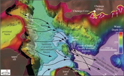
The team mapped at and below the sea floor, and then they compared results to earlier data. That data came from bathymetric measurements that had been taken throughout the waterways of southern Alaska during the 1930s and 1940s, mainly to map shallow water hazards in the land immediately below the water level.
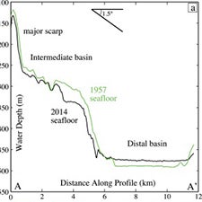
It quickly became apparent that the quake had dislodged a large moraine — a mass of sediment washed down by a melting glacier and perched precariously on an undersea ledge. The edge of the moraine was likely shaken loose by the quake and slid into the deep water channel of the Prince William Sound, causing a huge surge of water to inundate the shore at Chenega.
While this all may seem to be ancient history, it’s actually relevant to many living along coastal waters today.
“We’re learning that this quake was especially damaging to life and property because of all the glacial sediments built up in precarious positions,” Liberty said. “And it was a timing aspect where failure was just waiting to happen.”
Liberty notes that similar conditions are likely present in many fjords around the world, but data to systematically evaluate potential hazards is lacking. And as the population of coastal towns increases, so does the risk.
Knowing the danger could help save lives. “We aren’t any better at predicting earthquakes, but we are getting better at preparing for them,” he said.
BY: KATHLEEN TUCK PUBLISHED 9:54 AM / FEBRUARY 5, 2016